By Dr. Curtis Varnell
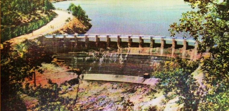
Four miles north of Belleville, Arkansas lies one of the best-kept secrets of Arkansas. The 82-acre lake was created in 1937. It has camping sites, picnic areas, and a fantastic swimming and boating area. On the south end of the lake is a beautiful dam created from native rock containing overflow outlets that allow torrents of water to cascade downward fifty feet or more before continuing down the nearby creek.
As a child, our church would hold picnics there each year. We would walk across the dam, enjoy the hiking, and play in the water that fell from the dam. Little did I realize that the deep waters of the lake held an even greater secret; it was the final resting and burial place for the small town of Stafford, Arkansas.
Located just North of Chickalah mountain, the area has a rich history. Frontier roads crisscrossed the area and served as paths for both Union and Confederate forces during the Civil war. Later, those same pathways were used by Belle Star and others as they visited relatives and friends in Yell County. Small farms dotted the area and inhabitants eked out a living growing crops, harvesting the hardwood forest, and hunting.
Stafford, one of several small community towns, developed to provide goods and services to these farm families. The Arkansas Gazette of 1898 states that the town had a population of 26 with H.R. McKinney as postmaster. It also contained a general store, a grist mill, and a church.
Local maps of the time period show a small dot and the name Stafford, located right in the middle of what is now Spring lake. The town has disappeared beneath the waters, a product of the economic woes of the depression. The 1930s were difficult times and jobs and money were hard to come by. Many of the people in Arkansas were dirt poor but land rich. In some cases, the federal government bought cheap land from destitute farmers in order to create the national forest or parkland. The CCC and WPA programs that began as part of the Roosevelt recovery plan offered jobs building roads, constructing parks, and building lakes. Like today, those jobs were tied to income and property ownership. Your ability to be offered a job was tied to the amount of property you owned and, if you wanted to work, good ole Uncle Sam was willing to buy your excess property at a very reasonable rate. There was a vast expansion of Arkansas property ownership by the national government. Traveling highway 10 from Belleville across country roads to highway 22 near New Blaine, there are no communities, no farms, and no longer a Stafford, Arkansas. Part of that purchased land became a national forest, scattered here and there by the developments on Magazine, Petit Jean, and Nebo Mountains.
In 1937, land was cleared, a large dam was constructed, and water began to cover the homes and businesses that once existed. Ed Grey, a local resident, remembers his dad taking him to the lake and pointing out foundations where the town once stood.
Today, I look down from the dam and my imagination takes me back to the time of my great grand-parents. I can see the large Stafford house, watch the children playing in the streets, and hear the church bell calling the community to worship in the town beneath the waves.


