

By Dr. Curtis Varnell
Wandering north of Lavaca on highway 96, I observed the sign directing toward Arbuckle Island. The name at once conjured up images of John Wayne, Indian raids, and wagon trains. Arbuckle was the man referred to when the military was needed to ride to the rescue of settlers, put down rebellions, or escort wagon trains headed to the gold field.
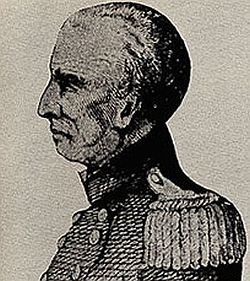
General Matthew Arbuckle was a career soldier and the son of a Revolutionary War hero by the same name. Born in 1778, he entered the military at an early age and is said to have been present with Andrew Jackson at the Battle of New Orleans. By the early 1820’s, he became commanding officer at Fort Smith and was in charge of maintaining peace between the natives and the settlers who were flooding into Arkansas. Deciding it would be easier to do his job further west, he established Fort Gibson and Fort Towson in Oklahoma Territory.
Arbuckle’s job not only included maintaining peace in the region but also in establishing roads and assisting wagon trains as they traveled to Santa Fe and later to the California gold rush. Locally, the military road that runs from Ft. Gibson, through Fort Smith and on to Dardanelle and Little Rock was built under his direction and with the assistance of his troops. For more than thirty years, he was the controlling military force on the frontier. For his service, he was awarded twenty thousand acres of land in Arkansas, most of it in Sebastian County. Arbuckle island comprised a large portion of that property. The family, Arbuckle never married but had numerous nephews and nieces, constructed a large two-story clapboard house, a slave quarters, and a cook house on what was known as the Arbuckle Plantation. The Crawford County courthouse, later moved to Van Buren, stood nearby. Many famous people, on their way westward, was said to have spent the night on the island.
Upon Arbuckle’s death in 1852, he was buried on the island and the property was shared between relatives and later sold and divided into several independent farms. By 1925, there were 75 homes, a school, a store, and several other businesses on the island. Rich farm land produced abundant produce and cotton. Picnics and events held on the island drew hundreds of people from communities in the area.
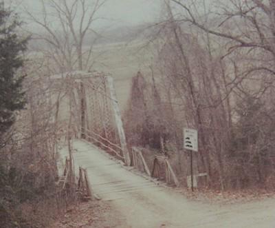
The problem with living on the island was the persistent flooding that occurred as the water levels of the river rose and subsided. One could reach the island by crossing a bridge on the east end or by catching a ferry to Mulberry or Dyer. When river levels rose to high, the slough under the bridge covered the road and made travel impossible. In 1916, the Arkansas river topped out at over ten foot above the flood stage. A big part of the island was inundated with water and boats had to evacuate the residents. Sand covered much of the land. Those that returned faced additional floods in 1923, 1926, and 1927. In 1926, the river cut a new channel through the middle of the island and left huge cliffs on the north side of the island. The eventual final nail in the coffin occurred in 1943 when the island was completely flooded and everything except a few foundations were destroyed.
Today, little is left on the island and much of the land is controlled by the Corps of Engineers. Former residents and family return to the cemetery on Decoration Days and recall the lives and times they once enjoyed. General Arbuckle, one of the most colorful and famous residents of Arkansas, resides, virtually unknown, under a nearby monument.


